
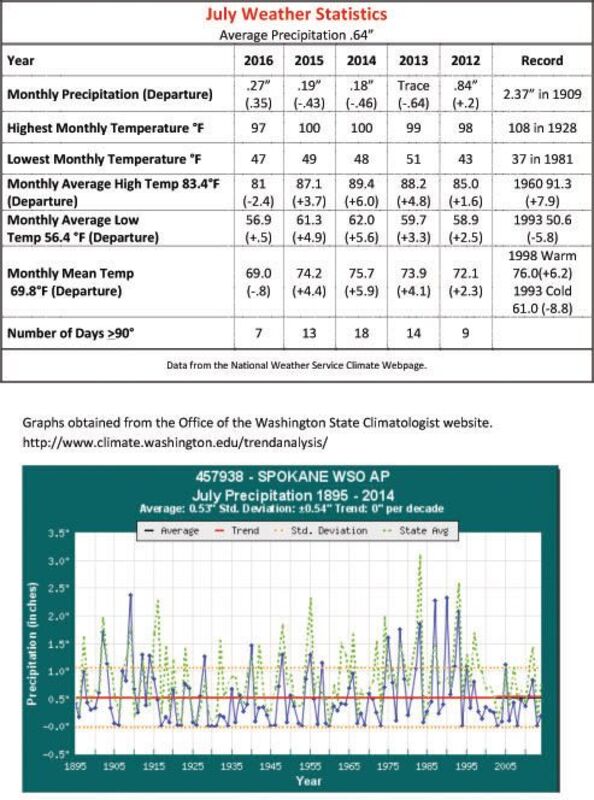
If it seemed as though the past month was just a bit cooler than a year ago, the statistics will back up that notion.
On average this past July was 6 degrees cooler than in 2015 and in terms of days over 100 and those in the 90s, the slam-dunk winner on the cool side was 2016 where not once did the mercury hit 100. Only seven days were in the 90s this past July where in 2015, there were 12.
What was the difference between the two years?
Retired Eastern Washington University meteorology professor, Bob Quinn, naturally had some answers.
"Normally in the summertime the water is cool in the North Pacific," Quinn said. When that happens, a thermal low will develop that ushers in desert heat from the Southwest. That was the case in 2015.
In these conditions, the mountains to the west are very effective in stopping the cool sea breezes.
"Every 10 days we get what we call 'a marine push,'" Quinn explained. "That's the normal summer weather, hot in the interior with an occasional marine push."
This year, what's a little bit different is the water in the ocean is warmer than normal. The change in the normal large high-pressure system is not as strong because the water is not as cool. "It's still (basically) the same normal summer pattern," Quinn said.
The weaker Pacific high allows storms to reach the Inland Northwest, where in 2015, the stronger high did not.
"This year we're not getting the blazing heat so the remainder of the season will be very much normal, just a bit cooler," Quinn said.
Precipitation is not much of a factor in the summer he said.
A wet July is hardly that, Quinn explained. "You get two little events with thunderstorms - you can get three-fourths of an inch in one storm - and you've already doubled July's total."
It does not take a lot in terms of moisture to make a wet July. Quinn said that in a half century of working with weather in the region, there are only a couple of summers he considers as being "truly wet."
The combination of lower temperatures and small amounts of rain did wonders for fire danger, which was in the moderate range in the third week of the month.
"Moderate in the middle of July is unheard of, " Quinn said.
Lower temperatures, coupled with lower fuel moisture is a good combination, but it was short-lived. After a strong and wet thunderstorm passed through the area July 22, the temperatures began to climb and the month finished with a string of six 90-degree days.
"With a cooler summer you get these episodes of marine pushes with the wind," Quinn explained. "The agony and ecstasy is that even in a cool summer, are the fuels dry enough to burn? Hell yes they are."
A series of dry weather fronts the past week has churned up the winds, and fires in Central Washington.
"You can still get a nasty fire day when the winds come through," Quinn said. "On balance you are certainly going to have a much lower fire danger and probably a lot less acres going up."
Those slightly warmer sea surface temperatures are a device of Mother Nature's own making, not the remnant of the two-year El Nino, which has dissipated.
"We have a potential La Nina (cooler sea surface temps), (but) I'm not ready to quite jump on board yet," Quinn said.
Paul Delaney can be reached at pdelaney@cheneyfreepress.com.

Reader Comments(0)