
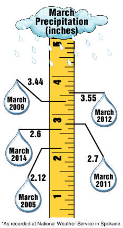
Area precipitation in March from 2005 to 2014 is shown above.
After a strange start, winter returned to normal in February.
And normal is what we can expect our spring to be according to Eastern Washington University meteorological and geography professor, Bob Quinn.
Minor cold snaps that took temperatures into the teens in December and January - thanks to a large stationary high-pressure ridge that sat over the Pacific Northwest for much of the fall and early winter - were all part of a puzzling start to the season that gave us an unseasonably low 9.8 inches of snow through January.
Such conditions, Quinn said, are not at all unusual. "What's unusual is once about every 10 years that becomes the dominant weather pattern all winter long."
But that pesky high finally went away in February, opening the door for a wet two months that brought snowfall totals to just shy of 38 inches. Normal snowfall at the National Weather Service office near Spokane International Airport is in the low to mid 40-inch range.
March certainly came in like the proverbial lion with 5.7 inches of snow in the first two days. The month ended with 2.6 inches of total precipitation, the fourth highest total in the past decade, behind 3.55 inches in 2012, 3.44 in 2009 and the 2.7 inches that fell in 2011.
That open spigot of Pacific Ocean moisture took snowpack in the Spokane basin from just 76 percent of normal in early January 2014 to 117 percent as of March 31. A more remarkable recovery occurred in the Olympic Peninsula which showed just 23 percent snow-water equivalent in January but now sits at 85.
It also brought a hefty dose of much-needed rain and snow to Northern and Central California. "This is too late to have a huge effect on their drought, but every little bit helps," Quinn said.
What changed?
"In the last month and a half, or so, the warm water pool - the core of it - has slowly drifted eastward to where it's now anchored right off the West Coast," Quinn said earlier this month.
The result was a cool trough. "Bingo, the end result was a pretty wet March," Quinn said. "Double the normal precip."
It was not the usual strong westerly fast-paced pattern but rather more of a cold upper level low-pressure system that sat over the region, Quinn explained.
"So you end up with those cool instability showers that every once in a while a system dropped down from the Aleutians into the low and then you would get an all night rain," he said.
The warm water pool is still there, Quinn explained. "It's beginning to weaken and I suspect by mid-spring or so, the end of May, it will be pretty much gone."
This is "The typical spring pattern," with a lot of disturbances rolling into the area. "Fast mover, quick shot of precip, wind, gone."
High pressure builds in behind it for a couple of days, the ridge begins to flatten and then midweek there's another trough moves up the coast, every 48-72 hours.
Temperatures will be pretty close to normal in the high 50s. Normal precipitation, near normal temperatures and a fast-paced storm track, he said.
"Basically I see that pattern holding through most of the spring," Quinn said.
And what about summer?
"It's a little too early to tell," Quinn said. "The big question is does that warm water pool eventually get destroyed and go away, which I suspect it will."
If it does, then it's easy, he said. "Normal summer, nothing outrageous, not exceptionally hot."
Paul Delaney can be reached at pdelaney@cheneyfreepress.com.

Reader Comments(0)